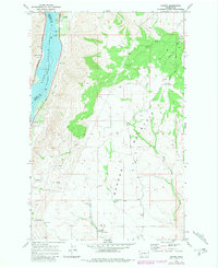
1968 Map of Orondo
USGS Topo · Published 1981About this map
The Lake Entiat shoreline and the high ridges of Badger Mountain dominate this Central Washington landscape during the late 1960s. The settlement of Orondo sits near the river's edge, serving as a hub where the Burlington Northern railroad corridor meets the base of the plateau. The map details a transition from the industrial and transport-heavy river valley, marked by a Pumping Sta and Rest Area, to the agricultural and recreational uplands. On the higher elevations of Badger Mtn, the presence of Ski Lifts and a Lookout Tower indicates a landscape utilized for both forest management and winter sports. Local community life is anchored in the south by the Badger Mtn Community Hall and the South Side Cem, while numerous Borrow Pits and storage facilities suggest an active economy built around local materials and land use.
Find a feature on this map
26 named features on this map. Tap any name to fly to it.
Don’t see what you’re looking for? This feature index may not catch every label — zoom into the map to look around manually.
Map Details
Editions of this 1968 Orondo Map
2 editions found

Other maps of this area

1901 · Chelan
USGS Topo · 1:125,000

1912 · Malaga
USGS Topo · 1:48,000

1913 · Wenatchee
USGS Topo · 1:62,500

1914 · Malaga
USGS Topo · 1:62,500

1915 · Wenatchee
USGS Topo · 1:62,500

1920 · Colockum Pass
USGS Topo · 1:125,000

1922 · Colockum Pass
USGS Topo · 1:125,000

1957 · Wenatchee
USGS Topo · 1:250,000
1966 · Malaga NE
USGS Topo · 1:24,000

1966 · Rock Island
USGS Topo · 1:24,000