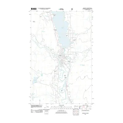
2011 Map of Oroville
USGS Topo · Published 2011About this map
Osoyoos Lake and the Similkameen River converge at Oroville, creating a landscape defined by its waterways and international proximity. This northern Washington community, situated just south of the Oroville-Osoyoos Port of Entry, serves as a critical junction where the river systems meet to form the Okanogan River. The local economy is represented by industrial landmarks like Zosels Mill and its associated Zosels Mill Pond Dam, while the rugged foothills are marked by the OK Copper Mine near Kruger Mountain. Transport patterns here are unique, featuring both the Dorothy Scott Airport and the Scott Seaplane Anchorage on the lake's western shore. Genealogists will find the Riverview Cemetery positioned overlooking the river valley, while the grid of Oroville includes the Oroville Post Office and various family-named roads such as Sprouse Rd and Thorndike Dr.
Find a feature on this map
67 named features on this map. Tap any name to fly to it.
Don’t see what you’re looking for? This feature index may not catch every label — zoom into the map to look around manually.
Map Details
Editions of this 2011 Oroville Map
This is the sole edition of this map. No revisions or reprints were ever made.
Other maps of this area

1902 · Osoyoos
USGS Topo · 1:125,000

1904 · Osoyoos
USGS Topo · 1:125,000

1906 · Chopaka
USGS Topo · 1:125,000

1954 · Okanogan
USGS Topo · 1:250,000

1956 · Loomis
USGS Topo · 1:62,500

1957 · Oroville
USGS Topo · 1:62,500

1958 · Okanogan
USGS Topo · 1:250,000

1975 · Oroville NW
USGS Topo · 1:24,000
1981 · Burge Mtn
USGS Topo · 1:24,000

1981 · Mount Hull
USGS Topo · 1:24,000