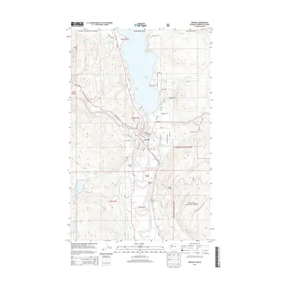
2014 Map of Oroville
USGS Topo · Published 2014About this map
The town of Oroville sits at a geographic crossroads in northern Washington, where the Similkameen River meets the Okanogan River just south of the international border. This survey details the complex water system that defines the local landscape, from the sprawling Osoyoos Lake crossing into Canada to smaller bodies like Hot Lake and Zosels Mill Pond. The terrain shifts from the heights of Kruger Mtn in the west down to the river islands of Driscoll Island and Eyhott Island. Local aviation history is represented by the Dorothy Scott Airport, while the Pacific NW National Scenic Trail winds through the valley. This 2014 record shows a community deeply integrated with its river valleys, maintaining older landmarks like the Riverview Cem while serving as a gateway for northern travel along the river corridors.
Find a feature on this map
72 named features on this map. Tap any name to fly to it.
Don’t see what you’re looking for? This feature index may not catch every label — zoom into the map to look around manually.
Map Details
Editions of this 2014 Oroville Map
This is the sole edition of this map. No revisions or reprints were ever made.
Other maps of this area

1902 · Osoyoos
USGS Topo · 1:125,000

1904 · Osoyoos
USGS Topo · 1:125,000

1906 · Chopaka
USGS Topo · 1:125,000

1954 · Okanogan
USGS Topo · 1:250,000

1956 · Loomis
USGS Topo · 1:62,500

1957 · Oroville
USGS Topo · 1:62,500

1958 · Okanogan
USGS Topo · 1:250,000

1975 · Oroville NW
USGS Topo · 1:24,000
1981 · Burge Mtn
USGS Topo · 1:24,000

1981 · Mount Hull
USGS Topo · 1:24,000