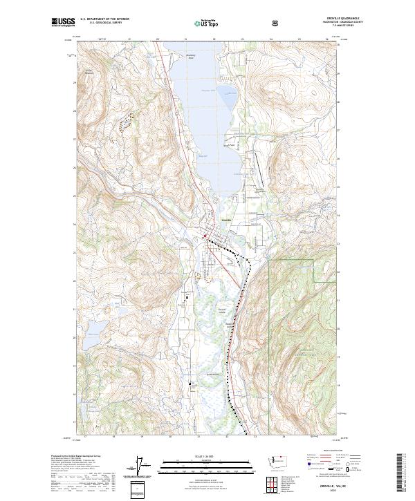
2023 Map of Oroville
USGS Topo · Published 2023About this map
The Similkameen River and Okanogan River meet just south of the international border in this 2023 survey of northern Okanogan County. At the center of this landscape is Oroville, a settlement defined by its position at the southern tip of Osoyoos Lake and its proximity to Boundary Point. The map illustrates the town's geography, including the Dorothy Scott Airport and a series of burial grounds such as the Oroville Riverview Cem and Old Oroville Cem. The surrounding terrain transitions from the slopes of Kruger Mountain to the protected expanse of the Okanogan National Forest in the east. Numerous small lakes and ponds, including Hot Lake and Johnny Johnson Lake, dot the highland benches, while the Pacific Northwest National Scenic Trl winds through the eastern hills, highlighting the area's significance for regional transit and recreation.
Find a feature on this map
80 named features on this map. Tap any name to fly to it.
Don’t see what you’re looking for? This feature index may not catch every label — zoom into the map to look around manually.
Map Details
Editions of this 2023 Oroville Map
This is the sole edition of this map. No revisions or reprints were ever made.
Other maps of this area

1902 · Osoyoos
USGS Topo · 1:125,000

1904 · Osoyoos
USGS Topo · 1:125,000

1906 · Chopaka
USGS Topo · 1:125,000

1954 · Okanogan
USGS Topo · 1:250,000

1956 · Loomis
USGS Topo · 1:62,500

1957 · Oroville
USGS Topo · 1:62,500

1958 · Okanogan
USGS Topo · 1:250,000

1975 · Oroville NW
USGS Topo · 1:24,000
1981 · Burge Mtn
USGS Topo · 1:24,000

1981 · Mount Hull
USGS Topo · 1:24,000