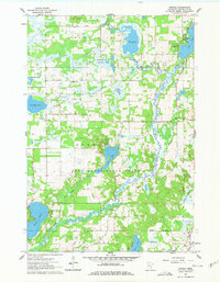
1961 Map of Orrock
USGS Topo · Published 1978About this map
The St Francis River winds through a complex landscape of glacial terrain and lowland wetlands in this Sherburne County survey. The Sand Dunes State Forest dominates the central portion of the map, where the Sand Dunes Lookout Tower stands as a focal point for conservation efforts in the early 1960s. This region is characterized by a series of distinct sloughs, including Beergerson Slough and Jensen Slough, reflecting the area's intricate drainage patterns.
Find a feature on this map
36 named features on this map. Tap any name to fly to it.
Don’t see what you’re looking for? This feature index may not catch every label — zoom into the map to look around manually.
Map Details
Editions of this 1961 Orrock Map
3 editions found
Other maps of this area

1953 · Stillwater
USGS Topo · 1:250,000

1955 · Stillwater
USGS Topo · 1:250,000

1958 · Stillwater
USGS Topo · 1:250,000

1961 · Big Lake
USGS Topo · 1:24,000

1961 · Orrock
USGS Topo · 1:24,000

1961 · Lake Fremont
USGS Topo · 1:24,000

1961 · Elk River
USGS Topo · 1:24,000

1961 · Monticello
USGS Topo · 1:24,000

1961 · Becker
USGS Topo · 1:24,000

1961 · Monticello
USGS Topo · 1:62,500