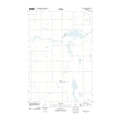
2010 Map of Orwell Lake
USGS Topo · Published 2010About this map
The small settlement of Western and its surrounding agricultural landscape define this portion of Otter Tail County in 2010. Significant water management and natural drainage are evident where the Otter Tail River is harnessed by the Orwell Dam, creating the Orwell Reservoir and Dam. This infrastructure sits in contrast to the natural curves of the Rabbit River and several glacial basins including Upper Lightning Lake and Faunce Lake. Local heritage and community focal points are preserved through the documentation of the Emmanuel Lutheran Church, the Emmanuel Lutheran Church Cemetery, and the Western Presbyterian Cemetery. The landscape is organized by a precise grid of county highways and local roads, such as County Hwy-15 and Dayton Hollow Rd, which serve the scattered farmsteads and rural residences of the township.
Find a feature on this map
31 named features on this map. Tap any name to fly to it.
Don’t see what you’re looking for? This feature index may not catch every label — zoom into the map to look around manually.
Map Details
Editions of this 2010 Orwell Lake Map
This is the sole edition of this map. No revisions or reprints were ever made.
Other maps of this area

1910 · Wendell
USGS Topo · 1:62,500

1913 · Fergus Falls
USGS Topo · 1:62,500

1913 · Wendell
USGS Topo · 1:62,500

1919 · Rothsay
USGS Topo · 1:62,500

1951 · Rothsay
USGS Topo · 1:62,500

1951 · Campbell
USGS Topo · 1:62,500

1953 · Fargo
USGS Topo · 1:250,000

1956 · Fargo
USGS Topo · 1:250,000

1966 · Carlisle
USGS Topo · 1:24,000
1973 · Dayton Hollow Dam
USGS Topo · 1:24,000