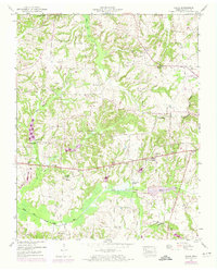
1950 Map of Osage
USGS Topo · Published 1974About this map
Cottage Grove and Osage anchor this survey of Henry County, which captures the rural landscape of northwest Tennessee as it transitioned into the mid-century. The terrain is defined by the Tennessee Valley Divide, where drainage patterns separate toward the Tennessee River and the Mississippi. Along the southern portion of the sheet, the Middle Fork Obion River winds through Ward Bottom, showing evidence of mid-century infrastructure with a Dam under construction noted near Trainer Creek.
Find a feature on this map
40 named features on this map. Tap any name to fly to it.
Don’t see what you’re looking for? This feature index may not catch every label — zoom into the map to look around manually.
Map Details
Editions of this 1950 Osage Map
3 editions found
Other maps of this area

1936 · Conyersville
USGS Topo · 1:24,000

1936 · Crossland
USGS Topo · 1:24,000

1936 · Mansfield
USGS Topo · 1:24,000

1936 · Paris
USGS Topo · 1:24,000

1950 · Osage
USGS Topo · 1:24,000

1950 · Paris
USGS Topo · 1:24,000

1950 · Mansfield
USGS Topo · 1:24,000

1950 · Puryear
USGS Topo · 1:24,000

1950 · Cottage Grove
USGS Topo · 1:24,000

1955 · Henry
USGS Topo · 1:24,000