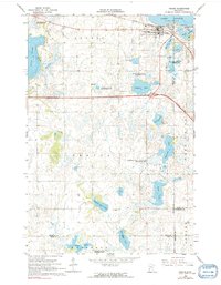
1966 Map of Osakis
USGS Topo · Published 1991About this map
The town of Osakis anchors this mid-1960s landscape, situated along the southern shore of Lake Osakis. The settlement's layout is defined by the Great Northern railroad line and a concentration of local institutions, including St Agnes Sch, Calvary Cem, and Evergreen Cem. The surrounding terrain transitions into a mosaic of wetlands and prairie lakes, including Smith Lake and Clifford Lake. The presence of several dedicated conservation zones, such as the Osakis State Wildlife Management Area and the Herberger Lake State Wildlife Management Area, indicates a landscape preserved for natural habitat even as industrial features like a Pipeline and multiple gravel pits begin to mark the outskirts. Genealogists may find the isolated English Grove Cem near English Grove Lake a significant point of interest for family research in rural Douglas County.
Find a feature on this map
35 named features on this map. Tap any name to fly to it.
Don’t see what you’re looking for? This feature index may not catch every label — zoom into the map to look around manually.
Map Details
Editions of this 1966 Osakis Map
2 editions found
Other maps of this area

1953 · Saint Cloud
USGS Topo · 1:250,000

1957 · Saint Cloud
USGS Topo · 1:250,000

1958 · Saint Cloud
USGS Topo · 1:250,000

1965 · Westport
USGS Topo · 1:24,000

1965 · Raymond Lake
USGS Topo · 1:24,000

1966 · West Union
USGS Topo · 1:24,000

1966 · Osakis
USGS Topo · 1:24,000

1966 · Lake Osakis East
USGS Topo · 1:24,000

1966 · Lake Osakis West
USGS Topo · 1:24,000

1966 · Alexandria East
USGS Topo · 1:24,000