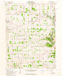
1961 Map of Osgood
USGS Topo · Published 1963About this map
The Treaty Line carves a significant historical diagonal across this landscape, separating the Congress Lands to the north from the Miami River Survey to the south. This boundary, rooted in the 1795 Treaty of Greenville, dictates the orientation of the local grid and farm lanes throughout Patterson and Marion townships. The agrarian character of the region is punctuated by a dense network of family-named roads, including Houschilt Road and Pittsenbarger Road, alongside several rural burial grounds such as Yoder Cem and English Cem. To the east, the Miami and Erie Canal (Abandoned) runs parallel to Loramie Creek, marking the path of 19th-century commerce that helped establish Fort Loramie. This survey also documents local industrial and resource extraction points like Gravel Pits, an Oil Well, and a Gas Well near the village of Osgood.
Find a feature on this map
55 named features on this map. Tap any name to fly to it.
Don’t see what you’re looking for? This feature index may not catch every label — zoom into the map to look around manually.
Map Details
Editions of this 1961 Osgood Map
3 editions found
Other maps of this area

1908 · St. Henry
USGS Topo · 1:62,500

1909 · Loramie
USGS Topo · 1:62,500

1911 · Loramie
USGS Topo · 1:62,500

1911 · Covington
USGS Topo · 1:62,500

1944 · Covington
USGS Topo · 1:62,500

1944 · Loramie
USGS Topo · 1:62,500

1953 · Muncie
USGS Topo · 1:250,000

1956 · Muncie
USGS Topo · 1:250,000

1961 · Dawn
USGS Topo · 1:24,000
1961 · Piqua West
USGS Topo · 1:24,000