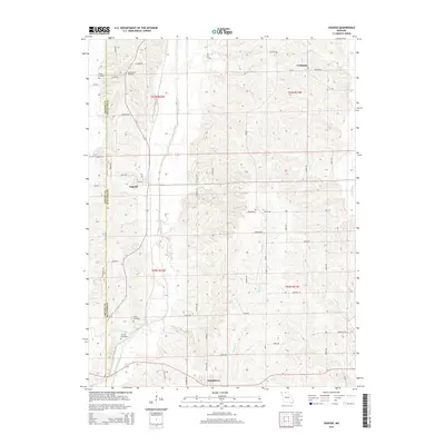
2014 Map of Osgood
USGS Topo · Published 2014About this map
Medicine Creek and Muddy Creek define the drainage of this Sullivan County landscape, where the rural settlements of Osgood and Humphreys serve as central points for the surrounding agricultural community. The terrain is a network of small tributaries and section lines, with the eastern edge bounded by West Locust Creek. Genealogists will find significant value in the distribution of family and community burial grounds across the township, including Maxey Cemetery, Union Grove Cemetery, Haley Cemetery, and Tunnell Cemetery. The map documents a highly developed local road network with distinctively named routes such as Litton Street and Raven Road. The boundary between Grundy and Sullivan counties is clearly delineated on the western side of the sheet, providing a precise reference for property and historical records.
Find a feature on this map
39 named features on this map. Tap any name to fly to it.
Don’t see what you’re looking for? This feature index may not catch every label — zoom into the map to look around manually.
Map Details
Editions of this 2014 Osgood Map
This is the sole edition of this map. No revisions or reprints were ever made.
Other maps of this area

1946 · Galt
USGS Topo · 1:62,500

1949 · Galt
USGS Topo · 1:62,500

1954 · Centerville
USGS Topo · 1:250,000

1957 · Centerville
USGS Topo · 1:250,000

1958 · Centerville
USGS Topo · 1:250,000

1964 · Harris
USGS Topo · 1:24,000
1964 · Browning
USGS Topo · 1:24,000

1964 · Half Rock
USGS Topo · 1:24,000

1964 · Milan West
USGS Topo · 1:24,000
1964 · Pollock SW
USGS Topo · 1:24,000