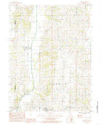
1984 Map of Osgood
USGS Topo · Published 1985About this map
Medicine Creek winds through the heart of this North Missouri landscape, tracing a north-south path that defines the local topography and drainage patterns. The map centers on the small rural settlements of Osgood and Humphreys, providing a clear look at their grid layouts and structural density in the early 1980s. This survey captures the transition between the agricultural uplands and the river bottomlands, with the Grundy County and Sullivan County border running along the western edge. Notable township divisions like Liberty, Bowman, and Myers are clearly delineated, offering essential reference points for researchers studying land ownership and civil boundaries. Smaller tributaries, including Muddy Creek and the western reaches of Locust Creek, further detail the drainage network that historically shaped the settlement patterns of this farming region.
Find a feature on this map
9 named features on this map. Tap any name to fly to it.
Don’t see what you’re looking for? This feature index may not catch every label — zoom into the map to look around manually.
Map Details
Editions of this 1984 Osgood Map
This is the sole edition of this map. No revisions or reprints were ever made.
Other maps of this area

1946 · Galt
USGS Topo · 1:62,500

1949 · Galt
USGS Topo · 1:62,500

1954 · Centerville
USGS Topo · 1:250,000

1957 · Centerville
USGS Topo · 1:250,000

1958 · Centerville
USGS Topo · 1:250,000

1964 · Harris
USGS Topo · 1:24,000
1964 · Browning
USGS Topo · 1:24,000

1964 · Half Rock
USGS Topo · 1:24,000

1964 · Milan West
USGS Topo · 1:24,000
1964 · Pollock SW
USGS Topo · 1:24,000