
2022 Map of Oshawa
USGS Topo · Published 2022About this map
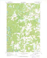
Oshawa centers this northern Minnesota landscape, where the boundary between Hubbard Co and Cass Co bisects a terrain of expansive wetlands and interconnected water systems. The map detail is dominated by the meandering course of Big Swamp Cr, which drains toward the southern reaches of the quadrangle. Small lakes like Mow Lake and Nagel Lake punctuate the northern edge, reflecting the post-glacial topography typical of this region. The settlement pattern follows a grid of local roads including Co 41 NW and Co 109, which navigate the marshy lowlands and provide access to the rural homesteads and timberlands that characterize the area's modern land use.
Find a feature on this map
31 named features on this map. Tap any name to fly to it.
Don’t see what you’re looking for? This feature index may not catch every label — zoom into the map to look around manually.
Map Details
Editions of this 2022 Oshawa Map
This is the sole edition of this map. No revisions or reprints were ever made.
Other maps of this area

1919 · Leader
USGS Topo · 1:62,500

1953 · Brainerd
USGS Topo · 1:250,000

1957 · Brainerd
USGS Topo · 1:250,000

1958 · Brainerd
USGS Topo · 1:250,000

1965 · Brainerd
USGS Topo · 1:250,000

1969 · Burgen Lake
USGS Topo · 1:24,000

1970 · Spider Lake
USGS Topo · 1:24,000

1970 · Backus
USGS Topo · 1:24,000

1970 · Hackensack
USGS Topo · 1:24,000
1970 · Bungo Creek
USGS Topo · 1:24,000