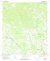
1977 Map of Osierfield
USGS Topo · Published 1991About this map
The Seaboard Coast Line railroad cuts a sharp diagonal across this South Georgia landscape, passing through the small community of Osierfield. This rural territory, spanning the borders of Ben Hill, Irwin, and Coffee Counties, is defined by its agrarian roots and family-named landmarks. Several small cemeteries, including Dicksons Cem and McMillan Cem, along with the Dicksons Millpond on Dicksons Mill Creek, suggest a long-established network of family farms and local milling operations.
Find a feature on this map
29 named features on this map. Tap any name to fly to it.
Don’t see what you’re looking for? This feature index may not catch every label — zoom into the map to look around manually.
Map Details
Editions of this 1977 Osierfield Map
2 editions found
Other maps of this area

1953 · Waycross
USGS Topo · 1:250,000

1958 · Waycross
USGS Topo · 1:250,000

1972 · Broxton North
USGS Topo · 1:24,000

1972 · Jacksonville
USGS Topo · 1:24,000

1972 · Fitzgerald East
USGS Topo · 1:24,000

1972 · Ambrose
USGS Topo · 1:24,000

1972 · China Hill
USGS Topo · 1:24,000

1972 · Ocilla East
USGS Topo · 1:24,000

1972 · Queensland
USGS Topo · 1:24,000

1977 · Osierfield
USGS Topo · 1:24,000