
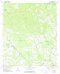
1977 Map of Osierfield
USGS Topo · Published 1977About this map
The Seaboard Coast Line railroad cuts diagonally through this South Georgia landscape, passing through the small community of Osierfield. This 1970s era documentation reveals a rural environment structured around water and family heritage, where the headwaters of Dicksons Mill Creek and Wiggins Creek feed into the Seventeen Mile River. The map shows a high concentration of local landmarks that anchor the community, including numerous country churches such as New Bethel Ch and Poplar Spring Ch.
Find a feature on this map
24 named features on this map. Tap any name to fly to it.
Don’t see what you’re looking for? This feature index may not catch every label — zoom into the map to look around manually.
Map Details
Editions of this 1977 Osierfield Map
2 editions found
Other maps of this area

1953 · Waycross
USGS Topo · 1:250,000

1958 · Waycross
USGS Topo · 1:250,000

1972 · Broxton North
USGS Topo · 1:24,000

1972 · Jacksonville
USGS Topo · 1:24,000

1972 · Fitzgerald East
USGS Topo · 1:24,000

1972 · Ambrose
USGS Topo · 1:24,000

1972 · China Hill
USGS Topo · 1:24,000

1972 · Ocilla East
USGS Topo · 1:24,000

1972 · Queensland
USGS Topo · 1:24,000
1977 · Queensland
USGS Topo · 1:24,000