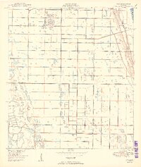
1950 Map of Oslo
USGS Topo · Published 1950About this map
Vero Beach and the small settlement of Oslo anchor the eastern coast of Florida in this mid-century survey, which details a landscape defined by drainage and early tourism. The presence of McKee Jungle Gardens highlights the era's emerging botanical attractions along the Atlantic coast, while the South Canal and numerous smaller water management features reveal the ongoing efforts to reclaim and structure the wetlands.
Find a feature on this map
17 named features on this map. Tap any name to fly to it.
Don’t see what you’re looking for? This feature index may not catch every label — zoom into the map to look around manually.
Map Details
Editions of this 1950 Oslo Map
2 editions found
Other maps of this area

1948 · Riomar
USGS Topo · 1:24,000

1948 · Indrio
USGS Topo · 1:24,000

1949 · Fort Pierce
USGS Topo · 1:24,000

1949 · Vero Beach
USGS Topo · 1:24,000

1949 · Oslo
USGS Topo · 1:24,000

1949 · Fort Pierce NW
USGS Topo · 1:24,000

1950 · Riomar
USGS Topo · 1:24,000

1950 · Fort Pierce
USGS Topo · 1:24,000

1950 · Fort Pierce NW
USGS Topo · 1:24,000

1950 · Oslo
USGS Topo · 1:24,000