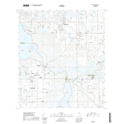
2018 Map of Osteen
USGS Topo · Published 2018About this map
The Saint Johns River and Lake Monroe define the aquatic landscape of this Florida region, where the historical settlement of Osteen serves as a central hub near the Volusia and Seminole county line. The map illustrates a complex network of wetlands and waterways, including Brickyard Slough, Snake Creek, and Hickory Slough, which feed into Lake Jesup and the larger river system. Significant historical and archaeological interest is found at Indian Mound Village and Stone Island, reflecting the long-term human presence along these shores.
Find a feature on this map
96 named features on this map. Tap any name to fly to it.
Don’t see what you’re looking for? This feature index may not catch every label — zoom into the map to look around manually.
Map Details
Editions of this 2018 Osteen Map
This is the sole edition of this map. No revisions or reprints were ever made.
Other maps of this area

1949 · Osceola
USGS Topo · 1:24,000

1953 · Geneva
USGS Topo · 1:24,000

1955 · Orlando
USGS Topo · 1:250,000

1956 · Oviedo
USGS Topo · 1:24,000

1957 · Orlando
USGS Topo · 1:250,000

1958 · Orlando
USGS Topo · 1:250,000

1962 · Orlando
USGS Topo · 1:250,000

1962 · Casselberry
USGS Topo · 1:24,000
1964 · Orange City
USGS Topo · 1:24,000
1965 · Osteen
USGS Topo · 1:24,000