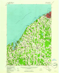
1960 Map of Oswego
USGS Topo · Published 1961About this map
Fort Ontario stands at the mouth of the river, guarding the harbor at Oswego where the New York Central railroad terminates at the lakefront. This 1960s-era coastal landscape is defined by the transition from urban shipping and the State Teachers College to the sprawling orchards and drumlin hills of the neighboring towns. Along the jagged shoreline, Fair Haven Beach State Park anchors the western edge near Little Sodus Bay, while the interior is dotted with rural hamlets like Southwest Oswego, Hannibal, and Sterling. Notable for genealogists are the numerous rural schoolhouses, including School No 18 and School No 7, and local religious landmarks such as St Joseph Chapel and Springbrook Chapel. The map reveals a land heavily shaped by post-glacial drainage, with intricate wetlands like Snake Swamp and numerous named elevations like Sidmans Hill that historically dictated the placement of pioneer roads and farmsteads.
Find a feature on this map
75 named features on this map. Tap any name to fly to it.
Don’t see what you’re looking for? This feature index may not catch every label — zoom into the map to look around manually.
Map Details
Editions of this 1960 Oswego Map
2 editions found
Other maps of this area

1900 · Baldwinsville
USGS Topo · 1:62,500

1900 · Oswego
USGS Topo · 1:62,500

1900 · Fulton
USGS Topo · 1:62,500

1902 · Sodus Bay
USGS Topo · 1:62,500

1902 · Clyde
USGS Topo · 1:62,500

1902 · Weedsport
USGS Topo · 1:62,500

1943 · Oswego East
USGS Topo · 1:31,680

1943 · Lysander
USGS Topo · 1:31,680

1943 · Oswego West
USGS Topo · 1:31,680

1943 · Cato
USGS Topo · 1:31,680