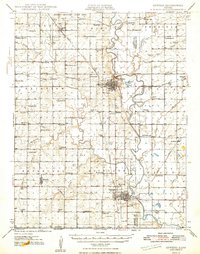
1948 Map of Oswego
USGS Topo · Published 1948About this map
The Neosho River meanders through the heart of this southeast Kansas landscape, serving as a focal point for the settlement patterns of Labette and Cherokee Counties in the 1940s. The city of Oswego sits prominently on the river's western bluffs, while the southern town of Chetopa serves as a vital junction near the Oklahoma border. A significant portion of the northern terrain is occupied by the Kansas Ordnance Plant Area, illustrating the impact of mid-century industrial and military infrastructure on the rural prairie.
Find a feature on this map
84 named features on this map. Tap any name to fly to it.
Don’t see what you’re looking for? This feature index may not catch every label — zoom into the map to look around manually.
Map Details
Editions of this 1948 Oswego Map
3 editions found
Other maps of this area

1886 · Joplin
USGS Topo · 1:125,000

1886 · Parsons
USGS Topo · 1:125,000

1893 · Parsons
USGS Topo · 1:125,000

1894 · Joplin
USGS Topo · 1:125,000

1901 · Vinita
USGS Topo · 1:125,000

1907 · Wyandotte
USGS Topo · 1:125,000

1909 · Wyandotte
USGS Topo · 1:125,000

1913 · Vinita
USGS Topo · 1:125,000

1918 · Columbus
USGS Topo · 1:62,500

1943 · McCune
USGS Topo · 1:62,500