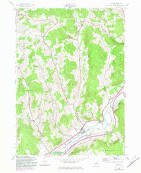
1943 Map of Otego
USGS Topo · Published 1983About this map
The Susquehanna River corridor forms the primary artery of this mid-century survey, where the Delaware and Hudson railroad tracks parallel the water through the valley floor. Settlement is concentrated along the southern river plains and the drainage of Otsdawa Creek, while the surrounding uplands in Butternuts and Morris maintain a sparse, rural character. The landscape is dotted with numerous family and community burial grounds, such as Evergreen Cem and Burdick Cem, which provide significant genealogical data for the region.
Find a feature on this map
40 named features on this map. Tap any name to fly to it.
Don’t see what you’re looking for? This feature index may not catch every label — zoom into the map to look around manually.
Map Details
Editions of this 1943 Otego Map
3 editions found
Other maps of this area

1910 · Hartwick
USGS Topo · 1:62,500

1910 · New Berlin
USGS Topo · 1:62,500

1912 · New Berlin
USGS Topo · 1:62,500

1912 · Hartwick
USGS Topo · 1:62,500

1915 · Oneonta
USGS Topo · 1:62,500

1915 · Unadilla
USGS Topo · 1:62,500

1918 · Unadilla
USGS Topo · 1:62,500

1918 · Oneonta
USGS Topo · 1:62,500

1943 · Mt Vision
USGS Topo · 1:24,000

1943 · New Berlin South
USGS Topo · 1:24,000