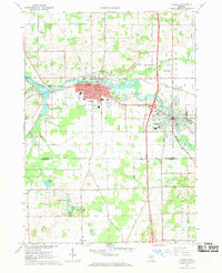
1967 Map of Otsego
USGS Topo · Published 1969About this map
The Kalamazoo River anchors this mid-century portrait of industrial and residential growth in Allegan County, flowing through the twin hubs of Otsego and Plainwell. The landscape is a mix of heavy infrastructure and established community life, evidenced by the presence of the Otsego Dam, the Plainwell Dam, and the Powerhouse. The Penn Central rail lines and the newly developed highway interchanges indicate a region deeply integrated into the state's transport network. Local genealogists will find significant detail in the residential layouts and the numerous community landmarks such as St Margaret Cem, Mountain Home Cem, and schools like the Jr High Sch and Dix Street Sch. To the south, the terrain transitions into the more rural landscape of Alamo, dotted with small water bodies like Ruppert Lake and Barbour Lake and various Gravel Pits that suggest the area's ongoing material industry.
Find a feature on this map
51 named features on this map. Tap any name to fly to it.
Don’t see what you’re looking for? This feature index may not catch every label — zoom into the map to look around manually.
Map Details
Editions of this 1967 Otsego Map
Other maps of this area

1916 · Kalamazoo
USGS Topo · 1:62,500

1918 · Kalamazoo
USGS Topo · 1:62,500

1943 · Kalamazoo
USGS Topo · 1:62,500

1946 · Gobles
USGS Topo · 1:62,500

1948 · Gobles
USGS Topo · 1:62,500

1949 · Gobles
USGS Topo · 1:62,500

1958 · Allegan
USGS Topo · 1:62,500

1958 · Grand Rapids
USGS Topo · 1:250,000

1959 · Wayland
USGS Topo · 1:62,500

1961 · Grand Rapids
USGS Topo · 1:250,000