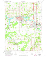
1967 Map of Otsego
USGS Topo · Published 1974About this map
The Kalamazoo River winds through the heart of this mid-century landscape, linking the industrial centers of Otsego and Plainwell. The map illustrates a period of expansion where established town grids meet newer infrastructure, including the Otsego-Plainwell Municipal Airport and the Penn Central rail line. Beyond the urban centers, the terrain transitions into the Gun Plain, a region characterized by numerous small lakes such as Ruppert Lake and Hipps Lake, and a network of rural avenues. Genealogical interest is high here, with several well-marked burial grounds including Mountain Home Cem, St Margaret Cem, and Woodside Cem. The presence of several Gravel Pits and industrial landmarks like the Otsego Dam and Powerhouse reflects the economic reliance on both the river and local mineral extraction during the late 1960s.
Find a feature on this map
68 named features on this map. Tap any name to fly to it.
Don’t see what you’re looking for? This feature index may not catch every label — zoom into the map to look around manually.
Map Details
Editions of this 1967 Otsego Map
Other maps of this area

1916 · Kalamazoo
USGS Topo · 1:62,500

1918 · Kalamazoo
USGS Topo · 1:62,500

1943 · Kalamazoo
USGS Topo · 1:62,500

1946 · Gobles
USGS Topo · 1:62,500

1948 · Gobles
USGS Topo · 1:62,500

1949 · Gobles
USGS Topo · 1:62,500

1958 · Allegan
USGS Topo · 1:62,500

1958 · Grand Rapids
USGS Topo · 1:250,000

1959 · Wayland
USGS Topo · 1:62,500

1961 · Grand Rapids
USGS Topo · 1:250,000