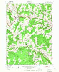
1943 Map of Otselic
USGS Topo · Published 1968About this map
The Otselic River valley serves as the primary corridor for settlement in this Chenango County landscape, as documented by the Army Map Service during the mid-1940s. The village of Otselic and the smaller hamlet of Otselic Center anchor the northwest, while the southern reaches are dominated by the Pharsalia Game Refuge. The map reveals a rural network defined by numbered schoolhouses and small crossroads such as Beaver Meadow and Stanbro, indicating a decentralized educational system typical of the era's town-based governance.
Find a feature on this map
30 named features on this map. Tap any name to fly to it.
Don’t see what you’re looking for? This feature index may not catch every label — zoom into the map to look around manually.
Map Details
Editions of this 1943 Otselic Map
3 editions found
Other maps of this area

1897 · Cazenovia
USGS Topo · 1:62,500

1899 · Cazenovia
USGS Topo · 1:62,500

1902 · Morrisville
USGS Topo · 1:62,500

1903 · Norwich
USGS Topo · 1:62,500

1904 · Pitcher
USGS Topo · 1:62,500

1943 · Otselic
USGS Topo · 1:24,000

1943 · West Eaton
USGS Topo · 1:24,000

1943 · South Ostelic
USGS Topo · 1:24,000
1943 · Erieville
USGS Topo · 1:24,000

1943 · Norwich
USGS Topo · 1:24,000