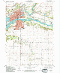
1994 Map of Ottawa
USGS Topo · Published 1994About this map
The confluence of the Fox River and the Illinois River shapes this detailed survey of Ottawa, Illinois, during the mid-1990s. The city's industrial and transport legacy is evident along the waterfront, where the Illinois and Michigan Canal St Trail runs parallel to the main river channel, passing through Allen Park and near the Marseilles Lock. Notable landforms like Hitt Island, Bulls Island, and Moores Island break the wide river course, while the surrounding tablelands of South Ottawa and Fall River are marked by extensive agricultural grids and the winding path of Covel Creek. Local history is deeply embedded in the numerous community landmarks, from the Courthouse downtown to a dense concentration of religious and educational institutions, including Marquette High Sch and St Columba Ch. The map also documents significant burial grounds such as Oakwood Memorial Park and Ottawa Ave Cem, serving as a vital record of the region's late 20th-century development.
Find a feature on this map
72 named features on this map. Tap any name to fly to it.
Don’t see what you’re looking for? This feature index may not catch every label — zoom into the map to look around manually.
Map Details
Editions of this 1994 Ottawa Map
This is the sole edition of this map. No revisions or reprints were ever made.
Other maps of this area

1892 · Marseilles
USGS Topo · 1:62,500

1892 · Ottawa
USGS Topo · 1:62,500

1915 · Ottawa
USGS Topo · 1:62,500

1916 · Marseilles
USGS Topo · 1:62,500

1925 · Streator
USGS Topo · 1:62,500

1927 · Streator
USGS Topo · 1:62,500

1940 · Marseilles
USGS Topo · 1:62,500

1946 · Ottawa
USGS Topo · 1:62,500

1958 · Odell
USGS Topo · 1:62,500

1958 · Aurora
USGS Topo · 1:250,000