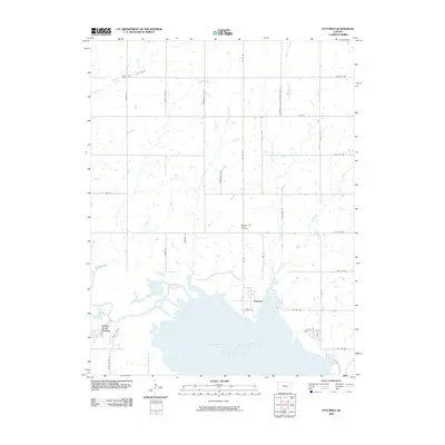
2009 Map of Ottumwa
USGS Topo · Published 2009About this map
The John Redmond Reservoir dominates the southern landscape of this Coffey County region, where the Neosho River valley was transformed by mid-century water management. The settlement of Ottumwa sits just north of the reservoir's expansive reach, positioned along a grid of rural roads such as Texas St and Iris Rd. This area preserves significant local history at the Bowman and Adgate Cemetery, located amidst a network of drainage creeks including Benedict Creek and Kennedy Creek. Further west, Jacobs Creek Landing serves as a point of access where Jacobs Creek meets the reservoir's northern finger. The map illustrates the transition from traditional prairie agriculture to a modern landscape defined by large-scale hydrology, while maintaining the established rural road network and isolated creek-side landmarks.
Find a feature on this map
38 named features on this map. Tap any name to fly to it.
Don’t see what you’re looking for? This feature index may not catch every label — zoom into the map to look around manually.
Map Details
Editions of this 2009 Ottumwa Map
This is the sole edition of this map. No revisions or reprints were ever made.
Other maps of this area

1885 · Burlington
USGS Topo · 1:125,000

1894 · Burlington
USGS Topo · 1:125,000

1947 · Lawrence
USGS Topo · 1:250,000

1950 · Lawrence
USGS Topo · 1:250,000

1956 · Lawrence
USGS Topo · 1:250,000

1957 · Lebo
USGS Topo · 1:24,000

1957 · Waverly NW
USGS Topo · 1:24,000
1957 · Lebo NW
USGS Topo · 1:24,000

1961 · Lawrence
USGS Topo · 1:250,000
1966 · John Redmond Dam
USGS Topo · 1:24,000