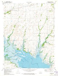
1970 Map of Ottumwa
USGS Topo · Published 1973About this map
The John Redmond Reservoir dominates the southern half of this landscape, where the Neosho River valley was transformed into a large-scale water management project. This 1970 survey captures the area following the reservoir's creation, showing numerous recreation zones such as the Strawn Recreation Area and the Hickory Creek East Recreation Area. The flooding of the valley altered the traditional geography of the Ottumwa township, yet several historical anchors remain on the higher ground.
Find a feature on this map
32 named features on this map. Tap any name to fly to it.
Don’t see what you’re looking for? This feature index may not catch every label — zoom into the map to look around manually.
Map Details
Editions of this 1970 Ottumwa Map
This is the sole edition of this map. No revisions or reprints were ever made.
Other maps of this area

1885 · Burlington
USGS Topo · 1:125,000

1894 · Burlington
USGS Topo · 1:125,000

1947 · Lawrence
USGS Topo · 1:250,000

1950 · Lawrence
USGS Topo · 1:250,000

1956 · Lawrence
USGS Topo · 1:250,000

1957 · Lebo
USGS Topo · 1:24,000

1957 · Waverly NW
USGS Topo · 1:24,000
1957 · Lebo NW
USGS Topo · 1:24,000

1961 · Lawrence
USGS Topo · 1:250,000
1966 · John Redmond Dam
USGS Topo · 1:24,000