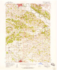
1956 Map of Ottumwa South
USGS Topo · Published 1958About this map
Des Moines River crossings and a dense network of early rural institutions define the landscape between Ottumwa and Bloomfield in the mid-1950s. The region is marked by a high concentration of country schools and churches, many already reflecting the shift in rural demographics, such as the Franklin Star Sch (Abandoned) and Stark Sch (Abandoned). Local centers like Agency, Floris, and Belknap are connected by a complex rail infrastructure including the Chicago Rock Island And Pacific and Wabash lines.
Find a feature on this map
105 named features on this map. Tap any name to fly to it.
Don’t see what you’re looking for? This feature index may not catch every label — zoom into the map to look around manually.
Map Details
Editions of this 1956 Ottumwa South Map
2 editions found
Other maps of this area

1954 · Centerville
USGS Topo · 1:250,000

1954 · Des Moines
USGS Topo · 1:250,000

1956 · Des Moines
USGS Topo · 1:250,000

1956 · Farson
USGS Topo · 1:24,000

1956 · Agency
USGS Topo · 1:24,000

1956 · Ottumwa North
USGS Topo · 1:62,500

1956 · Ottumwa South
USGS Topo · 1:24,000

1956 · Ottumwa South
USGS Topo · 1:62,500

1956 · Ottumwa North
USGS Topo · 1:24,000

1957 · Des Moines
USGS Topo · 1:250,000