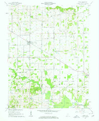
1961 Map of Otwell
USGS Topo · Published 1962About this map
Otwell serves as the primary hub in this early 1960s snapshot of the Pike Co Dubois Co line, where small crossroads communities and rural institutions define the landscape. The map reveals a high concentration of country churches and family-named burying grounds, including Traylor Union Ch and Bethel Cem, alongside specialized sites like the Otwell Holiness Camp.
Find a feature on this map
45 named features on this map. Tap any name to fly to it.
Don’t see what you’re looking for? This feature index may not catch every label — zoom into the map to look around manually.
Map Details
Editions of this 1961 Otwell Map
3 editions found
Other maps of this area

1902 · Ditney
USGS Topo · 1:125,000

1903 · Velpen
USGS Topo · 1:62,500

1944 · Glendale
USGS Topo · 1:24,000

1945 · Sandy Hook
USGS Topo · 1:24,000

1946 · Jasper
USGS Topo · 1:24,000

1954 · Huntingburg
USGS Topo · 1:24,000

1956 · Alfordsville
USGS Topo · 1:24,000

1956 · Vincennes
USGS Topo · 1:250,000

1957 · Vincennes
USGS Topo · 1:250,000

1958 · Vincennes
USGS Topo · 1:250,000