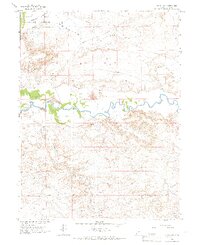
1964 Map of Ouray SE
USGS Topo · Published 1966About this map
The Ouray National Wildlife Refuge occupies the northwestern corner of this territory, where the bottomlands transition into the arid basins of Uintah County. The White River snakes eastward through the center of the sheet, its riparian corridor providing a stark contrast to the surrounding desert terrain. To the south, the landscape is defined by the significant topographic landmark of Mollys Nipple and the drainage of Cottonwood Wash.
Find a feature on this map
13 named features on this map. Tap any name to fly to it.
Don’t see what you’re looking for? This feature index may not catch every label — zoom into the map to look around manually.
Map Details
Editions of this 1964 Ouray SE Map
This is the sole edition of this map. No revisions or reprints were ever made.
Other maps of this area

1885 · East Tavaputs
USGS Topo · 1:250,000

1885 · Ashley
USGS Topo · 1:250,000

1907 · Jensen
USGS Topo · 1:125,000

1910 · Jensen
USGS Topo · 1:125,000

1917 · Vernal
USGS Topo · 1:125,000

1954 · Vernal
USGS Topo · 1:250,000

1956 · Grand Junction
USGS Topo · 1:250,000

1958 · Vernal
USGS Topo · 1:250,000

1959 · Grand Junction
USGS Topo · 1:250,000

1960 · Vernal
USGS Topo · 1:250,000