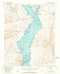
1953 Map of Overton Beach
USGS Topo · Published 1962About this map
The desert landscape of Clark County is defined here by the meeting of arid canyons and the rising waters of the Lake Mead National Recreation Area. In the early 1950s, the geography shows a transitional moment where the Virgin River and Muddy River flow into the northern reaches of the reservoir, creating a complex shoreline of inlets like Calico Bay and Echo Bay. The map documents the industrial and natural features of the era, from the Florence Mine and Nevada Silica Sand Mine near Kaolin to the protected lands of Valley of Fire State Park.
Find a feature on this map
60 named features on this map. Tap any name to fly to it.
Don’t see what you’re looking for? This feature index may not catch every label — zoom into the map to look around manually.
Map Details
Editions of this 1953 Overton Beach Map
4 editions found
Other maps of this area

1886 · Saint Thomas
USGS Topo · 1:250,000

1893 · Saint Thomas
USGS Topo · 1:250,000

1926 · Bonelli
USGS Topo · 1:96,000

1926 · Boulder Canyon
USGS Topo · 1:96,000

1953 · Muddy Peak
USGS Topo · 1:62,500

1953 · Overton Beach
USGS Topo · 1:62,500

1953 · Iceberg Canyon
USGS Topo · 1:62,500

1953 · Gold Butte
USGS Topo · 1:62,500

1953 · Hoover Dam
USGS Topo · 1:62,500

1953 · Virgin Basin
USGS Topo · 1:62,500