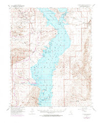
1953 Map of Overton Beach
USGS Topo · Published 1974About this map
Lake Mead National Recreation Area dominates this landscape where the Muddy River and Virgin River arms converge. The map illustrates the region as it transitioned into a major recreational and resource hub following the 1950s, with Overton Beach featuring a Boat Ramp and access to the Northshore Road. Resource extraction remains evident through the Florence Mine and Nevada Silica Sand Mine near Silica Dome, highlighting the geological industrial value of the area alongside the conserved lands of Valley of Fire State Park. The intricate desert hydrology is detailed through numerous seasonal drainages like Overton Wash and Rogers Wash, which lead into complex bays such as Calico Bay and Echo Bay. Scattered springs, including Blue Point Spring and Rogers Spr, provide vital points of interest for genealogists and local historians tracing early routes through this arid terrain.
Find a feature on this map
61 named features on this map. Tap any name to fly to it.
Don’t see what you’re looking for? This feature index may not catch every label — zoom into the map to look around manually.
Map Details
Editions of this 1953 Overton Beach Map
4 editions found
Other maps of this area

1886 · Saint Thomas
USGS Topo · 1:250,000

1893 · Saint Thomas
USGS Topo · 1:250,000

1926 · Bonelli
USGS Topo · 1:96,000

1926 · Boulder Canyon
USGS Topo · 1:96,000

1953 · Muddy Peak
USGS Topo · 1:62,500

1953 · Overton Beach
USGS Topo · 1:62,500

1953 · Iceberg Canyon
USGS Topo · 1:62,500

1953 · Gold Butte
USGS Topo · 1:62,500

1953 · Hoover Dam
USGS Topo · 1:62,500

1953 · Virgin Basin
USGS Topo · 1:62,500