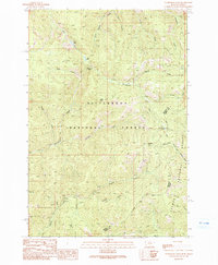
1991 Map of Overwhich Falls
USGS Topo · Published 1991About this map
The Bitterroot National Forest and Salmon National Forest meet at a high-elevation boundary along the Montana Idaho state line in this 1991 provisional survey. This territory is defined by steep drainages and isolated water bodies, most notably the namesake Overwhich Falls located along Overwhich Creek. The map documents a high-altitude landscape where the Ravalli and Lemhi county lines intersect with the rugged watershed of the North Fork Salmon River.
Find a feature on this map
30 named features on this map. Tap any name to fly to it.
Don’t see what you’re looking for? This feature index may not catch every label — zoom into the map to look around manually.
Map Details
Editions of this 1991 Overwhich Falls Map
2 editions found
Other maps of this area

1955 · Dillon
USGS Topo · 1:250,000

1956 · Elk City
USGS Topo · 1:250,000

1957 · Dillon
USGS Topo · 1:250,000

1958 · Dillon
USGS Topo · 1:250,000

1960 · Elk City
USGS Topo · 1:250,000

1960 · Piquett Mountain
USGS Topo · 1:62,500

1962 · Dillon
USGS Topo · 1:250,000

1964 · Piquett Creek
USGS Topo · 1:24,000

1965 · Dillon
USGS Topo · 1:250,000

1965 · Medicine Hot Springs
USGS Topo · 1:24,000