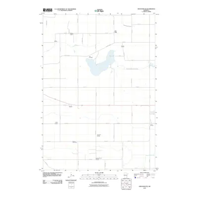
2010 Map of Owatonna SE
USGS Topo · Published 2010About this map
Rice Lake serves as the central focal point of this rural landscape in southeastern Minnesota, regulated by the Rice Lake Dam. The terrain is defined by the headwaters of several significant drainage systems, including the Middle Fork Zumbro River and the South Branch Middle Fork Zumbro River, which wind through a grid of agricultural section lines. This area is notably dense with small, localized burial grounds that suggest the deep-rooted settlement patterns of the township. Genealogists can trace family histories through sites such as the Aurora Lutheran Cemetery, Saint John's Lutheran Cemetery, and the German Methodist Episcopal Cemetery. The map also preserves the locations of the Thompson Cemetery and Dania Cemetery, alongside recreational features like the Havana Hills Golf Course and water management structures such as the Moonan Marsh Dam. The extensive road network, including County HWY-19, illustrates the enduring rural infrastructure of the region in the early twenty-first century.
Find a feature on this map
49 named features on this map. Tap any name to fly to it.
Don’t see what you’re looking for? This feature index may not catch every label — zoom into the map to look around manually.
Map Details
Editions of this 2010 Owatonna SE Map
This is the sole edition of this map. No revisions or reprints were ever made.
Other maps of this area

1953 · Saint Paul
USGS Topo · 1:250,000

1954 · Mason City
USGS Topo · 1:250,000

1957 · Mason City
USGS Topo · 1:250,000

1958 · Mason City
USGS Topo · 1:250,000

1959 · Saint Paul
USGS Topo · 1:250,000

1962 · Medford East
USGS Topo · 1:24,000

1962 · Owatonna
USGS Topo · 1:24,000

1962 · Moland
USGS Topo · 1:24,000

1962 · Owatonna SE
USGS Topo · 1:24,000

1965 · Claremont
USGS Topo · 1:24,000