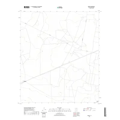
2019 Map of Owego
USGS Topo · Published 2019About this map
Baldridge anchors this landscape in Pecos County, characterized by a network of rural routes that facilitate movement through this part of West Texas. The infrastructure is defined by key thoroughfares like Owego Rd and Woodward Rd, which cross the terrain and connect isolated points of interest. This 2019 survey documents a region where the vast topography is punctuated by subtle man-made features, reflecting the enduring pattern of ranching or energy-related land use in the Texas interior. The sparse naming of features suggests a focused geographic area where individual landmarks and specific road junctions carry significant local weight for navigation and land ownership.
Find a feature on this map
3 named features on this map. Tap any name to fly to it.
Don’t see what you’re looking for? This feature index may not catch every label — zoom into the map to look around manually.
Map Details
Editions of this 2019 Owego Map
This is the sole edition of this map. No revisions or reprints were ever made.
Other maps of this area
1928 · Crane
USGS Topo · 1:125,000
1928 · Comanche Spring
USGS Topo · 1:125,000
1929 · Independence Draw Quadrangle
USGS Topo · 1:125,000

1954 · Pecos
USGS Topo · 1:250,000

1954 · Fort Stockton
USGS Topo · 1:250,000

1957 · Pecos
USGS Topo · 1:250,000

1958 · Fort Stockton
USGS Topo · 1:250,000
1969 · Bootleg Canyon
USGS Topo · 1:24,000
1970 · East Mesa
USGS Topo · 1:24,000
1970 · Saddle Butte
USGS Topo · 1:24,000