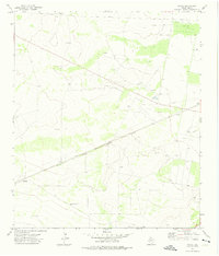
1972 Map of Owego
USGS Topo · Published 1975About this map
The Atchison Topeka and Santa Fe railroad cuts a diagonal line across this Pecos County landscape, serving as the primary corridor for movement and industrial activity during the early 1970s. The region is defined by its extraction economy, with the Owego Oil Field and Sun Valley Oil Field blanketing the northern and central sections with a dense network of infrastructure. These fields are marked by numerous Oil Wells, Drill Holes, and a significant Pipeline system. Smaller rail-side settlements like Owego and Baldridge appear as quiet outposts in this arid terrain, while the Johnson Windmill to the south suggests the vital role of water management in a ranching landscape that exists alongside the petroleum rigs. The map reveals the precise distribution of gravel pits and wells that sustained local operations during this era of West Texas energy development.
Find a feature on this map
14 named features on this map. Tap any name to fly to it.
Don’t see what you’re looking for? This feature index may not catch every label — zoom into the map to look around manually.
Map Details
Editions of this 1972 Owego Map
This is the sole edition of this map. No revisions or reprints were ever made.
Other maps of this area

1928 · Crane
USGS Topo · 1:125,000

1928 · Comanche Spring
USGS Topo · 1:125,000

1929 · Independence Draw Quadrangle
USGS Topo · 1:125,000

1954 · Pecos
USGS Topo · 1:250,000

1954 · Fort Stockton
USGS Topo · 1:250,000

1957 · Pecos
USGS Topo · 1:250,000

1958 · Fort Stockton
USGS Topo · 1:250,000

1969 · Bootleg Canyon
USGS Topo · 1:24,000

1970 · East Mesa
USGS Topo · 1:24,000
1970 · Saddle Butte
USGS Topo · 1:24,000