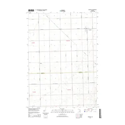
2014 Map of Owendale
USGS Topo · Published 2014About this map
Owendale stands as the primary settlement in this corner of Michigan's Thumb region, situated where Sebewaing Rd meets Owendale Rd. The landscape is defined by the straight lines of the Public Land Survey System, with roads like Canboro Rd and Rescue Rd following section lines across a predominantly agricultural plain. The boundary between Huron Co and Tuscola Co bisects the map horizontally, roughly following Huron Line Rd, providing a clear look at how county jurisdictions organized the rural landscape. To the west, the small hamlet of Bach sits at the intersection of Bach Rd and Bayport Rd. Natural drainage is provided by the meandering courses of Shebeon Cr and Swamp Cr, which offer a sharp contrast to the rigid geometry of the surrounding farm blocks and rural transport network.
Find a feature on this map
82 named features on this map. Tap any name to fly to it.
Don’t see what you’re looking for? This feature index may not catch every label — zoom into the map to look around manually.
Map Details
Editions of this 2014 Owendale Map
This is the sole edition of this map. No revisions or reprints were ever made.
Other maps of this area
1954 · Flint
USGS Topo · 1:250,000
1958 · Flint
USGS Topo · 1:250,000
1963 · Cass City
USGS Topo · 1:24,000
1963 · Ellington
USGS Topo · 1:24,000
1963 · Gagetown
USGS Topo · 1:24,000
1963 · Owendale
USGS Topo · 1:24,000
1963 · Colling
USGS Topo · 1:24,000
1963 · Sebewaing
USGS Topo · 1:24,000
1970 · Bay Port West
USGS Topo · 1:24,000
1970 · Bay Port East
USGS Topo · 1:24,000