
1963 Map of Sebewaing
USGS Topo · Published 1965About this map
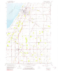
Saginaw Bay defines the western edge of this coastal Michigan landscape, where the Sebewaing River meets the shoreline. In the early 1960s, the village of Sebewaing serves as a hub for both transportation and regional agriculture, supported by the Chesapeake and Ohio railroad and the Sebewaing Airport. The interior of the sheet reveals an intricate network of drainage systems such as Gremel Drain and State Drain, which turned the low-lying terrain into productive farmland.
Find a feature on this map
61 named features on this map. Tap any name to fly to it.
Don’t see what you’re looking for? This feature index may not catch every label — zoom into the map to look around manually.
Map Details
Editions of this 1963 Sebewaing Map
2 editions found
Other maps of this area

1954 · Flint
USGS Topo · 1:250,000

1958 · Flint
USGS Topo · 1:250,000

1963 · Fish Point
USGS Topo · 1:24,000

1963 · Fairgrove
USGS Topo · 1:24,000

1963 · Ellington
USGS Topo · 1:24,000

1963 · Owendale
USGS Topo · 1:24,000

1963 · Colling
USGS Topo · 1:24,000

1970 · Bay Port West
USGS Topo · 1:24,000

1970 · Bay Port East
USGS Topo · 1:24,000
1984 · Bay City
USGS Topo · 1:100,000