
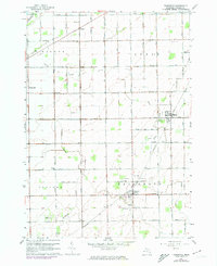
1963 Map of Fairgrove
USGS Topo · Published 1964About this map
Fish Point Wildlife Area and the marshy shores of Saginaw Bay define the northwestern corner of this landscape, where the land meets the water. Moving inland, the terrain is dominated by the organized grid of Tuscola County agriculture and the extraction of local resources. An extensive system of drainage, including the Northwest Drain, Allen Drain, and Soper Drain, crisscrosses the township boundaries of Wisner, Akron, Gilford, and Fairgrove. The local economy of the early 1960s is represented by a cluster of wells in the central Oil Field and the Chesapeake and Ohio railroad corridor that connects the village of Akron to Fairgrove. Small social centers are anchored by local institutions such as Battelle Sch and several country churches, including Wisner Ch and Grace Ch, which served the surrounding farmsteads and rural residents.
Find a feature on this map
43 named features on this map. Tap any name to fly to it.
Don’t see what you’re looking for? This feature index may not catch every label — zoom into the map to look around manually.
Map Details
Editions of this 1963 Fairgrove Map
2 editions found
Other maps of this area

1954 · Flint
USGS Topo · 1:250,000

1958 · Flint
USGS Topo · 1:250,000

1963 · Quanicassee
USGS Topo · 1:24,000

1963 · Fish Point
USGS Topo · 1:24,000

1963 · Reese
USGS Topo · 1:24,000

1963 · Gilford
USGS Topo · 1:24,000

1963 · Caro
USGS Topo · 1:24,000

1963 · Colling
USGS Topo · 1:24,000

1963 · Sebewaing
USGS Topo · 1:24,000
1984 · Flint
USGS Topo · 1:100,000