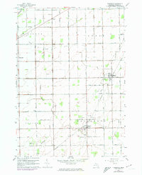
1963 Map of Fairgrove
USGS Topo · Published 1974About this map
The agricultural landscape of Tuscola County meets the marshes of Saginaw Bay in this 1963 survey, revised in the early 1970s. The region is defined by an extensive network of drainage systems, including the Northwest Drain, Allen Drain, and Soper Drain, which support the surrounding productive fields. In the northern reaches, the Fish Point Wildlife Area preserves the shoreline habitat, while further inland, the Oil Field indicates the subsurface industry of the mid-century era.
Find a feature on this map
55 named features on this map. Tap any name to fly to it.
Don’t see what you’re looking for? This feature index may not catch every label — zoom into the map to look around manually.
Map Details
Editions of this 1963 Fairgrove Map
2 editions found
Other maps of this area

1954 · Flint
USGS Topo · 1:250,000

1958 · Flint
USGS Topo · 1:250,000

1963 · Quanicassee
USGS Topo · 1:24,000

1963 · Fish Point
USGS Topo · 1:24,000

1963 · Fairgrove
USGS Topo · 1:24,000

1963 · Reese
USGS Topo · 1:24,000

1963 · Gilford
USGS Topo · 1:24,000

1963 · Caro
USGS Topo · 1:24,000

1963 · Colling
USGS Topo · 1:24,000

1963 · Sebewaing
USGS Topo · 1:24,000