
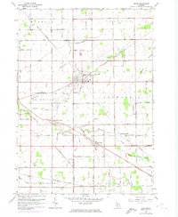
1963 Map of Reese
USGS Topo · Published 1964About this map
The village of Reese sits at the strategic junction of the New York Central and Chesapeake and Ohio railroads, anchoring a productive agricultural landscape on the border of Saginaw and Tuscola Counties. In the early 1960s, this region was defined by its intricate drainage network, including Squaw Creek and Reese Drain, which facilitated the cultivation of the surrounding townships. Smaller agricultural hamlets like Richville and Blumfield Corners are centered around local services and religious landmarks such as St Elizabeth Cem and the Townhall. The map reveals the precise layout of the rail-and-road economy, from the siding at Denmark Junction to the outlying station at Tuscola Sta, documenting a period when these small rail hubs were still central to the movement of goods in mid-Michigan.
Find a feature on this map
51 named features on this map. Tap any name to fly to it.
Don’t see what you’re looking for? This feature index may not catch every label — zoom into the map to look around manually.
Map Details
Editions of this 1963 Reese Map
2 editions found
Other maps of this area

1916 · Bay City
USGS Topo · 1:62,500

1919 · Bay City
USGS Topo · 1:62,500

1919 · Saginaw
USGS Topo · 1:62,500

1941 · Saginaw
USGS Topo · 1:62,500

1943 · Bay City
USGS Topo · 1:62,500

1943 · Saginaw
USGS Topo · 1:62,500

1954 · Flint
USGS Topo · 1:250,000

1958 · Flint
USGS Topo · 1:250,000

1963 · Quanicassee
USGS Topo · 1:24,000

1963 · Fairgrove
USGS Topo · 1:24,000