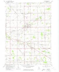
1963 Map of Reese
USGS Topo · Published 1974About this map
The agricultural landscape of the Thumb region is defined by a dense network of drainage channels and small hamlets during the mid-1960s. The village of Reese serves as a central hub where the Chesapeake and Ohio and Penn Central railroads intersect, supporting the local farming economy. To the southwest, the town of Richville sits near the crossing of Sheboygan Creek, while smaller communities like Blumfield Corners and Denmark Junction mark local crossroads. The map reveals the intricate water management system essential to the area, featuring numerous man-made ditches such as Ryan Drain, Reese Drain, and Tinglan Drain. For genealogists, the survey identifies local landmarks including the Arn Sch, St Elizabeth Cem, and the Blumfield Cem. These details illustrate the transition from early 20th-century rural settlement patterns to a modernizing agricultural district just before significant suburban shifts reached this part of Tuscola County.
Find a feature on this map
50 named features on this map. Tap any name to fly to it.
Don’t see what you’re looking for? This feature index may not catch every label — zoom into the map to look around manually.
Map Details
Editions of this 1963 Reese Map
2 editions found

Other maps of this area

1916 · Bay City
USGS Topo · 1:62,500

1919 · Bay City
USGS Topo · 1:62,500

1919 · Saginaw
USGS Topo · 1:62,500

1941 · Saginaw
USGS Topo · 1:62,500

1943 · Bay City
USGS Topo · 1:62,500

1943 · Saginaw
USGS Topo · 1:62,500

1954 · Flint
USGS Topo · 1:250,000

1958 · Flint
USGS Topo · 1:250,000

1963 · Quanicassee
USGS Topo · 1:24,000

1963 · Fairgrove
USGS Topo · 1:24,000