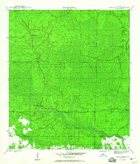
1946 Map of Owens Bridge
USGS Topo · Published 1960About this map
Apalachicola National Forest dominates this mid-1940s landscape, illustrating a vast expanse of wetland terrain and timberland along the border of Liberty and Franklin counties. The hydrological network is the primary feature of this quadrangle, defined by the winding course of the New River and its various tributaries including Juniper Creek, Cat Branch, and Nero Branch.
Find a feature on this map
12 named features on this map. Tap any name to fly to it.
Don’t see what you’re looking for? This feature index may not catch every label — zoom into the map to look around manually.
Map Details
Editions of this 1946 Owens Bridge Map
4 editions found
Other maps of this area

1944 · Pickett Bay
USGS Topo · 1:31,680

1944 · Queens Bay
USGS Topo · 1:24,000

1945 · Thousand Yard Bay
USGS Topo · 1:31,680

1945 · Smith Creek
USGS Topo · 1:31,680

1945 · Tates Hell Swamp
USGS Topo · 1:31,680

1945 · Pickett Bay
USGS Topo · 1:31,680

1945 · Fort Gadsden
USGS Topo · 1:31,680

1946 · Queens Bay
USGS Topo · 1:31,680

1946 · Sumatra
USGS Topo · 1:31,680

1946 · Owens Bridge
USGS Topo · 1:31,680