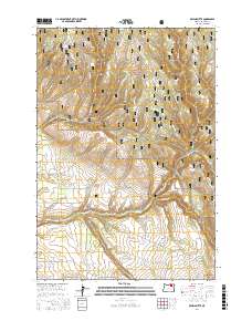
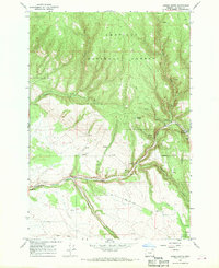
2017 Map of Owens Butte
USGS Topo · Published 2017About this map
Umatilla National Forest encompasses much of this high-country landscape, where the terrain is defined by a series of steep drainages and timbered ridges. The namesake Owens Butte stands as a prominent landmark overlooking a network of Forest Service development roads that provide access to the backcountry. This 2017 survey details the complex hydrography of the region, anchored by the winding course of Camas Cr and its many tributaries, including Hidaway Cr and Queens Cr. The presence of Hidaway Springs Rd and Cable Ck Rd suggests the historical and continued importance of these corridors for forest management and recreation. The map meticulously traces the transition from the upland basins of Lane Cr to the lower reaches of Pine Cr, illustrating a remote section of Umatilla County characterized by its deep canyons and managed forest lands.
Find a feature on this map
40 named features on this map. Tap any name to fly to it.
Don’t see what you’re looking for? This feature index may not catch every label — zoom into the map to look around manually.
Map Details
Editions of this 2017 Owens Butte Map
This is the sole edition of this map. No revisions or reprints were ever made.
Other maps of this area

1953 · Pendleton
USGS Topo · 1:250,000

1956 · Pendleton
USGS Topo · 1:250,000
1967 · Ukiah SE
USGS Topo · 1:24,000
1967 · Lehman Springs
USGS Topo · 1:24,000
1967 · Granite Meadows
USGS Topo · 1:24,000
1967 · Pearson Ridge
USGS Topo · 1:24,000
1967 · Bridge Creek
USGS Topo · 1:24,000
1967 · Carney Butte
USGS Topo · 1:24,000
1967 · Ukiah
USGS Topo · 1:24,000
1967 · Owens Butte
USGS Topo · 1:24,000