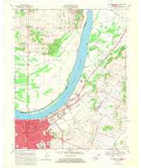
1967 Map of Owensboro East
USGS Topo · Published 1970About this map
The Ohio River dominates this landscape, serving as the historical and geographic boundary between Indiana and Kentucky. On the southern bank, the city of Owensboro shows a dense urban grid of residential and educational growth, featuring institutions like Brescia College and Technical High Sch. The river itself is punctuated by Yellow Bank Island and Beeler Island, which shift the main channel and create a complex system of sloughs and drains such as Isaac Wright Drain. This era of the late 1960s captures the expansion of suburban Owensboro toward Thruston, with prominent spiritual and civic landmarks like the Monastery and White Chapel Memorial Gardens established along the periphery of the river valley. The Louisville and Nashville railroad infrastructure remains a central artery for the region's transport, connecting industrial riverfront sites with the interior settlement of Patronville across the water in Spencer County.
Find a feature on this map
77 named features on this map. Tap any name to fly to it.
Don’t see what you’re looking for? This feature index may not catch every label — zoom into the map to look around manually.
Map Details
Editions of this 1967 Owensboro East Map
3 editions found
Other maps of this area

1901 · Owensboro
USGS Topo · 1:62,500

1903 · Tell City
USGS Topo · 1:62,500

1906 · Sutherland
USGS Topo · 1:62,500

1907 · Whitesville
USGS Topo · 1:62,500

1909 · Whitesville
USGS Topo · 1:62,500

1952 · Owensboro East
USGS Topo · 1:24,000

1952 · Rockport
USGS Topo · 1:24,000

1952 · Owensboro West
USGS Topo · 1:24,000

1953 · Philpot
USGS Topo · 1:24,000

1953 · Sutherland
USGS Topo · 1:24,000