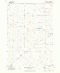
1977 Map of Owl Butte SE
USGS Topo · Published 1978About this map
South Sulphur Creek and Elm Creek wind through the open rangeland of Butte County in the late 1970s. The landscape is characterized by its drainage patterns and the established township boundaries of Union. This area reflects the mid-century agricultural footprint of Western South Dakota, where water sources dictated the placement of small rural hubs. The settlement of Acme appears as a quiet focal point in this sparsely populated region, showing the infrastructure of a ranching community during this period of the twentieth century. Detailed topographic work from aerial photography taken in 1972 reveals the subtle contours of the plains and the essential network of light-duty roads that connected these remote prairie locales.
Find a feature on this map
4 named features on this map. Tap any name to fly to it.
Don’t see what you’re looking for? This feature index may not catch every label — zoom into the map to look around manually.
Map Details
Editions of this 1977 Owl Butte SE Map
This is the sole edition of this map. No revisions or reprints were ever made.
Other maps of this area

1913 · Newell
USGS Topo · 1:125,000

1953 · Rapid City
USGS Topo · 1:250,000

1957 · Rapid City
USGS Topo · 1:250,000
1959 · Volunteer NW
USGS Topo · 1:24,000
1959 · Volunteer NE
USGS Topo · 1:24,000

1959 · Fairpoint NW
USGS Topo · 1:24,000
1973 · Owl Butte
USGS Topo · 1:24,000
1977 · Deers Ears Butte South
USGS Topo · 1:24,000

1977 · Table Top Butte
USGS Topo · 1:24,000
1978 · Owl Butte NE
USGS Topo · 1:24,000