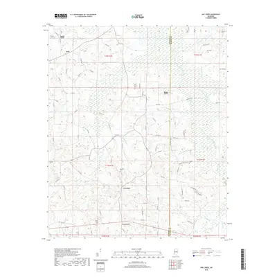
2018 Map of Owl Creek
USGS Topo · Published 2018About this map
Bogue Chitto and the eastern edge of Neshoba County define this landscape, where the namesake Bogue Chitto waterway and its tributaries, including Owl Creek and Cope Creek, wind through the terrain. The map documents a dispersed pattern of rural settlements such as North Bend, Bond, Forestdale, and Crossroads, connected by a web of county roads and Bureau of Indian Affairs routes like BIA Rd 231. This geography is particularly significant for genealogists, as it preserves the locations of numerous family and community burial grounds, including Roundtree Cemetery, Hensons Cemetery, and Long Cemetery. The proximity of Henson Cemetery Rd and Mount Salem Rd suggests the historical importance of these sites to the local identity. The mapping of Rea Ditch and various branches like Mayo Branch and Sorghum Branch provides a detailed look at the local drainage systems that have influenced land use in this part of Mississippi.
Find a feature on this map
85 named features on this map. Tap any name to fly to it.
Don’t see what you’re looking for? This feature index may not catch every label — zoom into the map to look around manually.
Map Details
Editions of this 2018 Owl Creek Map
This is the sole edition of this map. No revisions or reprints were ever made.
Other maps of this area

1953 · Meridian
USGS Topo · 1:250,000

1957 · Meridian
USGS Topo · 1:250,000

1962 · House
USGS Topo · 1:24,000

1962 · Lynville
USGS Topo · 1:24,000

1962 · Vernon
USGS Topo · 1:24,000

1962 · Owl Creek
USGS Topo · 1:24,000

1962 · Preston
USGS Topo · 1:24,000

1962 · Moscow
USGS Topo · 1:24,000

1965 · Meridian
USGS Topo · 1:250,000
1972 · Noxapater
USGS Topo · 1:24,000