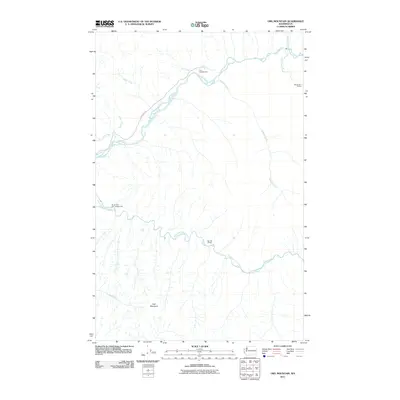
2011 Map of Owl Mountain
USGS Topo · Published 2011About this map
The Hoh River and its southern fork dominate this terrain as they flow westward through the Olympic Peninsula’s dense river valleys. Access into this wild landscape is limited to the Upper Hoh Rd along the northern bank, leading toward the Hoh Campground. The topography is defined by the significant rise of Owl Mountain in the south, where numerous tributaries like Owl Creek drain toward the South Fork Hoh River. This 2011 survey documents the infrastructure provided for back-country navigation, including the Big Flat Shelter and Mount Tom Shelter, alongside the South Fork Hoh Campground. These markers indicate a landscape managed for recreation and preservation, where the glacial-fed waters of Mineral Creek and Jackson Creek meet the primary river systems in a deeply carved drainage pattern.
Find a feature on this map
16 named features on this map. Tap any name to fly to it.
Don’t see what you’re looking for? This feature index may not catch every label — zoom into the map to look around manually.
Map Details
Editions of this 2011 Owl Mountain Map
This is the sole edition of this map. No revisions or reprints were ever made.
Other maps of this area

1939 · Mount Tom
USGS Topo · 1:62,500

1943 · Spruce Mountain
USGS Topo · 1:62,500

1943 · Copalis Beach
USGS Topo · 1:250,000

1950 · Slide Peak
USGS Topo · 1:24,000
1950 · Bogachiel Peak
USGS Topo · 1:24,000

1951 · Copalis Beach
USGS Topo · 1:250,000

1956 · Kloochman Rock
USGS Topo · 1:62,500

1956 · Mount Tom
USGS Topo · 1:62,500

1956 · Spruce Mtn.
USGS Topo · 1:62,500

1956 · Salmon River
USGS Topo · 1:62,500