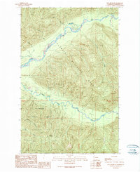
1990 Map of Owl Mountain
USGS Topo · Published 1990About this map
The Hoh River and South Fork Hoh River carve through this corner of the Olympic Peninsula, where deep rainforest valleys meet the steep slopes of Owl Mountain. In 1990, the landscape was defined by the transition between the Olympic National Park and the Olympic National Forest. The map documents the established recreation and administrative infrastructure of the era, including the Hoh Ranger Station, an Amphitheater, and the Hoh Rain Forest Campground.
Find a feature on this map
25 named features on this map. Tap any name to fly to it.
Don’t see what you’re looking for? This feature index may not catch every label — zoom into the map to look around manually.
Map Details
Editions of this 1990 Owl Mountain Map
This is the sole edition of this map. No revisions or reprints were ever made.
Other maps of this area

1939 · Mount Tom
USGS Topo · 1:62,500

1943 · Spruce Mountain
USGS Topo · 1:62,500

1943 · Copalis Beach
USGS Topo · 1:250,000

1950 · Slide Peak
USGS Topo · 1:24,000
1950 · Bogachiel Peak
USGS Topo · 1:24,000

1951 · Copalis Beach
USGS Topo · 1:250,000

1956 · Kloochman Rock
USGS Topo · 1:62,500

1956 · Mount Tom
USGS Topo · 1:62,500

1956 · Spruce Mtn.
USGS Topo · 1:62,500

1956 · Salmon River
USGS Topo · 1:62,500