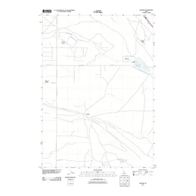
2010 Map of Owyhee
USGS Topo · Published 2010About this map
The Idaho State Penitentiary and the Idaho State Correctional Institution dominate the northern landscape of this 2010 Ada County survey, highlighting the area's role in the state's institutional infrastructure. Situated south of Boise, the terrain is defined by a network of seasonal watercourses including Tenmile Creek, Indian Creek, and Sand Creek that cut across the high desert plain. Small settlements such as Owyhee and Pleasant Valley are linked by long thoroughfares like Kuna Mora Rd and Pleasant Valley Rd. In the northeast, the Blacks Creek Dam creates the Blacks Creek Reservoir, a significant water feature in this arid environment. The map also captures specialized land uses such as the Blacks Creek Rifle Range and Airstrip Access, illustrating a mix of public safety, water management, and rural transport.
Find a feature on this map
23 named features on this map. Tap any name to fly to it.
Don’t see what you’re looking for? This feature index may not catch every label — zoom into the map to look around manually.
Map Details
Editions of this 2010 Owyhee Map
This is the sole edition of this map. No revisions or reprints were ever made.
Other maps of this area

1892 · Boise
USGS Topo · 1:125,000

1892 · Bisuka
USGS Topo · 1:125,000

1894 · Bisuka
USGS Topo · 1:125,000

1897 · Boise
USGS Topo · 1:125,000

1953 · Cloverdale
USGS Topo · 1:24,000

1954 · Boise South
USGS Topo · 1:24,000

1954 · Boise
USGS Topo · 1:62,500

1955 · Christmas Mtn
USGS Topo · 1:24,000
1955 · Coyote Butte
USGS Topo · 1:24,000

1955 · Orchard
USGS Topo · 1:24,000