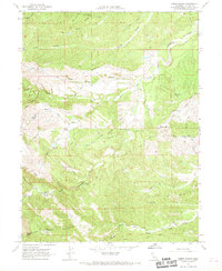
1967 Map of Oxbow Bridge
USGS Topo · Published 1968About this map
Oxbow Bridge spans a complex drainage network in Tehama County, where the South Fork Cottonwood Creek and Cold Fork carve through the landscape. This 1967 field-checked study reveals a ranching and transport environment defined by numerous named flats and seasonal watercourses. To the southwest, Deadman Crossing marks a significant point of passage near Mud Spring Valley, while family-named landmarks like Pettyjohn Scofield Flat suggest the area's grazing history.
Find a feature on this map
43 named features on this map. Tap any name to fly to it.
Don’t see what you’re looking for? This feature index may not catch every label — zoom into the map to look around manually.
Map Details
Editions of this 1967 Oxbow Bridge Map
2 editions found
Other maps of this area

1890 · Red Bluff
USGS Topo · 1:250,000

1894 · Red Bluff
USGS Topo · 1:250,000

1947 · Anderson
USGS Topo · 1:62,500

1948 · Anderson
USGS Topo · 1:62,500

1949 · Colyear Springs
USGS Topo · 1:62,500

1952 · Blossom
USGS Topo · 1:24,000

1952 · Red Bank
USGS Topo · 1:24,000

1952 · Ono
USGS Topo · 1:62,500

1952 · Red Bank
USGS Topo · 1:62,500

1957 · Colyear Springs
USGS Topo · 1:62,500