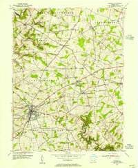
1953 Map of Oxford
USGS Topo · Published 1955About this map
Lincoln University anchors the center of this southern Chester County landscape, surrounded by a dense network of nineteenth-century townships like Lower Oxford and Upper Oxford. The borough of Oxford serves as the primary regional hub, where several roads and the Pennsylvania Railroad line converge. Beyond the town centers, the land is defined by a deep-rooted rural infrastructure of country schools and churches, including the Chestnut Grove Sch and Beulah Ch. The terrain is etched by the winding course of Elk Creek and its many branches, which cut through the agricultural plateaus. This mid-century survey reveals a transition in transportation, showing the enduring prominence of local landmarks like Faggs Manor and Daleville alongside the established Baltimore Pennsylvania and Pike.
Find a feature on this map
53 named features on this map. Tap any name to fly to it.
Don’t see what you’re looking for? This feature index may not catch every label — zoom into the map to look around manually.
Map Details
Editions of this 1953 Oxford Map
4 editions found
Other maps of this area

1898 · Elkton
USGS Topo · 1:62,500

1900 · Elkton
USGS Topo · 1:62,500

1900 · Havre De Grace
USGS Topo · 1:62,500

1904 · Coatesville
USGS Topo · 1:62,500

1906 · Coatesville
USGS Topo · 1:62,500

1912 · Quarryville
USGS Topo · 1:62,500

1917 · Elkton
USGS Topo · 1:62,500

1918 · Coatesville
USGS Topo · 1:62,500

1942 · Havre De Grace
USGS Topo · 1:62,500

1942 · Elkton
USGS Topo · 1:62,500
Featured Places
- New London Township, PA
- Upper Oxford Township, PA
- Russellville, Upper Oxford Township
- Lower Oxford Township, PA
- East Nottingham Township, PA